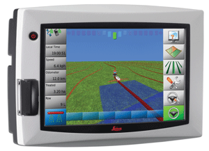
 Leica Geosystems is represented here at Commodity Classic by Harlan Little, North American Business Manager. He showed me information that has just been released about their new mojo3D which puts mapping and guidance in a “new perspective.”
Designed to help growers get the job done more quickly and efficiently, the system combines a unique, three-dimensional user interface with rugged, water-resistant metal hardware built to withstand tough rural conditions.
With a large 7” touch-screen display and high-quality three-dimensional graphics, the Leica mojo3D has been built for ease of use. It has an intuitive, icon-based menu structure and setup wizards to minimize the time it takes to set the controls and get on with the task at hand. Users can change settings quickly and easily by tapping the relevant icon, without having to navigate away from the main guidance screen.
 Users can customize the Leica mojo3D to meet individual requirements, with a range of option packs available, including terrain-compensated electric auto-steer via the Leica QuickSteer motor and Leica TWIST terrain compensation unit. Single section or multi-section control to reduce overlap and misses in spraying, spreading and planting applications is also available. Additionally, users have the option to upgrade auto-steer accuracy to 2cm RTK positioning with the Leica mojoRTK.
The Leica mojo3D may be pre-ordered now, and will begin shipping March 29. For more information about the Leica mojo3D and other ag guidance solutions from Leica Geosystems visit www.AgGuidance.com.
I interviewed Harlan and you can learn all about the new features and benefits of the new mojo3D in our discussion. He also talks about the mojoMINI which he’s holding in his hands in the photo.
You can listen to my interview with Harlan below.
AgWired coverage of the 2010 Commodity Classic
is sponsored by:  and
and 
