
How to get maximum value from satellite monitoring: EOS Crop Monitoring case study
Sponsored content provided for AgWired by EOS Crop Monitoring
Finding the reason behind low field performance could be tricky. Often seems there were no pests and fertilizers properly applied, but somehow results are unsatisfactory. EOS Crop Monitoring case study illustrates how satellite data enables problem-solving on a field.
Satellite monitoring in a nutshell
Satellite crop monitoring is an online-based technology that enables ground surface analysis for vegetation levels assessment. This allows to track plant development dynamics and identify problem spots on a field without leaving the office. Other features include weather prediction tools, rainfall information, and field historical data. Insights from satellites are visualized in software platforms for efficient field management.
How to detect issues on a field via satellites
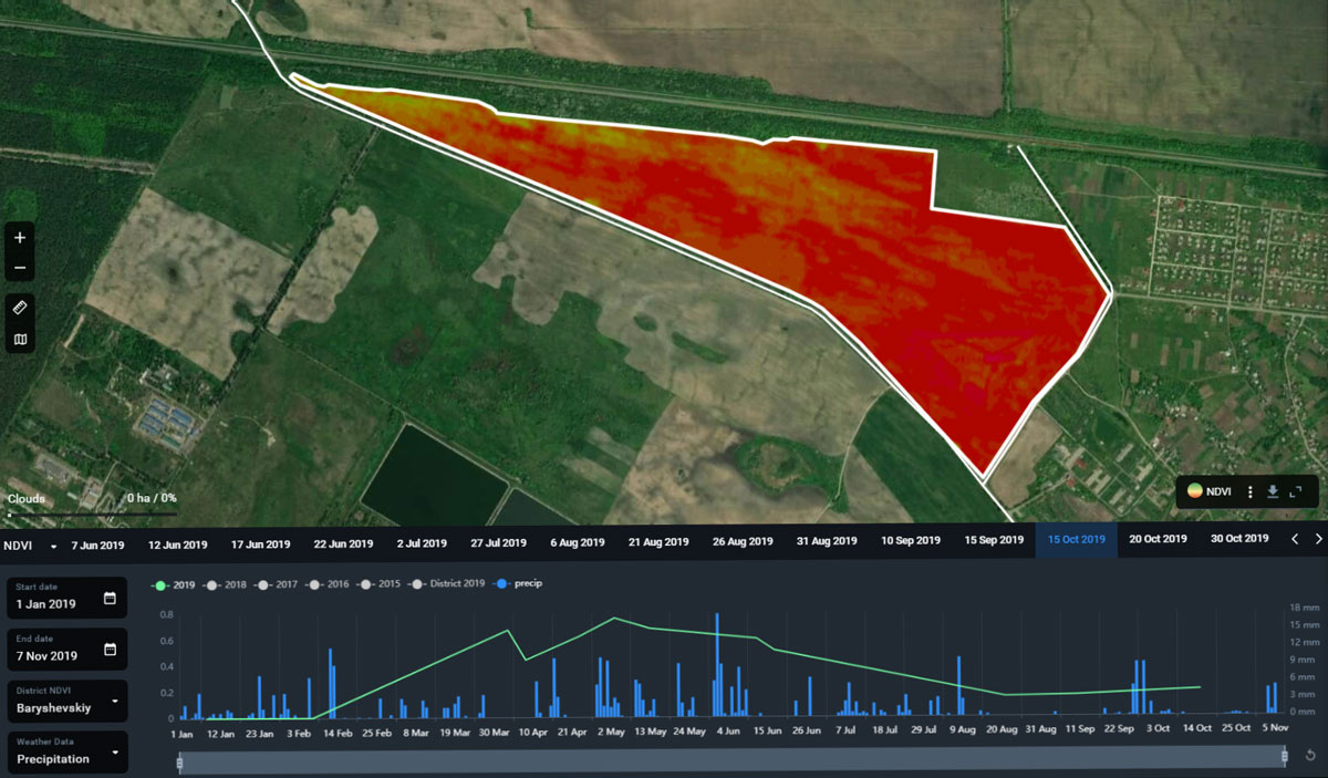 In October 2019, EOS Crop Monitoring team was requested to identify the reason behind low NDVI readings. NDVI (normalized difference vegetation index) is a formula that estimates near-infrared light reflected from the Earth’s surface to assess vegetation conditions. The platform reported sparse plant performance which in NDVI spectra is visualized in shades of red. (click on image for larger version)
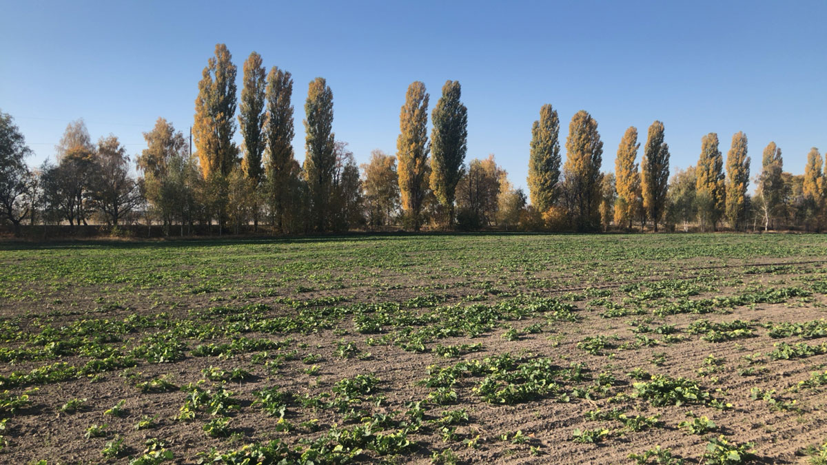
And in order to examine sprouts conditions, the EOS team joined up with an agronomist and traveled to the area. Pictures directly from the field confirmed low quantity and quality of the sprouts:
 Since the main condition for successful rapeseed growth on its initial stages is high soil moisture levels, the first thing the EOS team examined was available data that had the biggest impact on this parameter. Though Crop Monitoring does not measure soil moisture levels directly (the feature will be added soon), it revises rainfall records on specific areas for several years. By comparing the sowing date (August 13th, 2019) with relevant entries in August-September, EOS scouts have seen that the latest minor rains were gone a couple of days before the sowing. And since the August 13th until the middle of September there were none whatsoever:
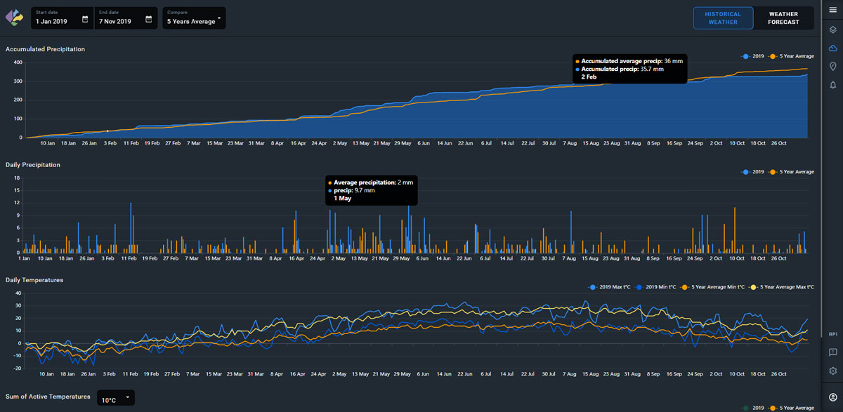 According to the field agronomist, lack of rainfall is the main reason for overdried soil which eventually caused vegetation failures. This theory was confirmed after comparing the level of vegetation in the researched area with the neighboring rapeseed field which was sown ten days prior, caught the rain, and did not suffer from poor vegetation.
As a result, with the help of the EOS Crop Monitoring, the farmer was able to graphically see the problem as well as its cause. Understanding the core of the issue helps to avoid mistakes in the future as the platform provides data and notifications on weather conditions, showing when additional watering is necessary.
More about EOS Crop Monitoring
Besides the information about rainfalls, EOS Crop Monitoring allows to precisely measure field areas, monitor the plant health performance, alert on dangerous weather conditions, as well as saves these valuable records in its database. Depending on the landbank layout the cost-advantage of the satellite crop monitoring technology might reach from 5 to 20 %.